Fifteen days on the Big SEKI, July 4–18. I started at Roads End, climbed out of Kings Canyon on Copper Creek, and worked clockwise through the high country: south along the JMT, over Kearsarge and back, down the Kern, then west across Kaweah Gap and north over Elizabeth Pass. Back to Roads End by way of Deadman Canyon, Roaring River, and Avalanche Pass.
The group changed a lot along the way. G, Mi, Ma, and I started together, with Is and Iz turning back to the car early and rejoining at Onion Valley for the second half. A JMT crew met us at Lake Marjorie, G and Mi left from there, and Ma and W left at Onion Valley.
Day 1 · July 4: Roads End to Granite Lake
Day 1 was a real slog up the mountain out of Copper Creek. We took frequent breaks so folks could catch up and acclimate, and around 7,500 feet Is said a rest was needed, having been nauseous since the day before. What was meant to be a 20-minute break turned into something much longer. G, Mi, Ma, and I continued on and reached the lip around 4 pm, above the point where we entered Granite Basin. The wildflowers started popping there: penstemons, phlox, fleabanes, all kinds of stuff.
The descent into the basin was lovely, with open views most of the way, but the low spots near Granite Creek were mosquito-infested. We arrived at Granite Lake around 6:45 pm with loads of daylight and not another soul in sight. The clouds lit up pink and orange a bit later, and by nightfall we were blanketed and warm, eerily too warm for 10,000 feet in early July. There was very little snow on the north faces of the basin peaks.
Approx. distance: about 10.5 miles.
Camp: Granite Lake.
Day 2 · July 5: Granite Lake to Simpson Meadow
Day 2 started warm and cloudy, and we had to throw our flies on in the middle of the night for some drizzle. There were more gorgeous flowers on the way up to Granite Pass, and huge 360° views at the top, with massive peaks and layered landscapes. We lunched at Dougherty Creek (technically above it, away from the mosquitoes), then made a small climb before starting the descent I'd been dreading: 4,000 feet over four or five miles.
Mi's knee started causing a lot of pain on the way down, so we went slowly for much of it. We passed through a few ecotones and an area that had burned in the last decade or so, judging by the manzanita scrub. Oaks reappeared around 7,000 feet, with lupines and thimbleberries (not yet fruiting) a little lower. We scrambled a bit to find a camp at Simpson Meadow, but G found an old trail crew camp near the river on the upper Middle Fork Kings. I slept super well. The meadow was dry and the river was running fast and low.
Approx. distance: about 13.5 miles.
Camp: Old trail crew camp near the Middle Fork Kings, by Simpson Meadow.
Day 3 · July 6: Up the Middle Fork Kings
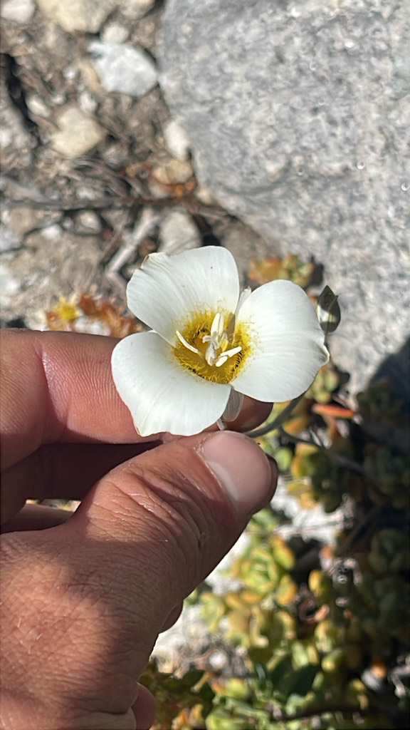
I spent most of the day in awe of the aqua-blue water of the Middle Fork and the imposing rocky faces of the canyon walls. Flowers galore: mints, lilies, columbines, and monkeyflowers. The mariposa lily below was from this stretch.
Ma hit a wall about a third of the way into the day, and her feet were causing her a lot of pain. There were tears and pep talks. We arrived at camp around 6:30 with enough light left to dip our legs in the river for a while while G fly fished and Mi read on the bank. The highlight of the day was the first view of a seemingly endless chain of waterfalls. G fished a big hole under a fall and caught a couple.
I was hoping Ma would feel better on the way up to Palisades the next day. Is and Iz had gone back to the car and planned to reevaluate again that day.
Approx. distance: about 8 miles.
Camp: Confluence of Palisade Creek and the Middle Fork Kings.
Day 4 · July 7: Palisade Creek to Lower Palisade Lake
A short day up alongside Palisade Creek, our first retracing of the JMT. Ma's feet felt a lot better, despite walking wet for the first part of the day after crossing Palisade Creek first thing. There were some new flowers along the way, particularly in the meadows: owl's clover, and a purple flower with a single white variant.
The Golden Staircase was a fun climb that got us into a good rhythm. We lunched partway up, maybe a third of the way, and I dunked my socks and shoes and looked at the twinberries fruiting alongside the little stream. We passed tons of northbound PCT folks, upwards of 40, I would guess.
We arrived at Lower Palisade Lake around 2:30 and I immediately went for a dip and rinse off the gravelly sand bar. Frigid, but so refreshing. G fished some, then Ma and Mi arrived and we decided to just stay put for the night. The afternoon was reading, water play, dinner, and cards, then stargazing before bed. Very few mosquitoes up here.
Approx. distance: about 7 miles.
Camp: Lower Palisade Lake.
Day 5 · July 8: Mather Pass to Lake Marjorie
We got an earlier start (8 am) out of Palisades so we could get up and over Mather Pass at a decent hour. I saw a few new alpine wildflowers on the ascent and descent, and the climb out of Palisades was beautiful. For the future, there are some sites near Middle Palisades by a creek, but they're at higher elevation.
Atop Mather Pass I had my first up-close pika interaction, a cute little gray one eating grass just off the trail. We took a midday dip in the South Fork Kings River, where I convinced Ma to ice her feet before the piney climb up to Marjorie. I didn't clearly remember the area around Marjorie. It was a smoky day for us two years ago and we pushed past it, so we might have been out of it or in the zone.
There are some red-rock peaks up here, and the granite chunks around the lake are dotted with stubby whitebark pines. Not much shade, and the wind was a nuisance until the sun mostly set. No mosquitoes up here, and the stars were out in full force.
The JMT crew was set to meet us at Marjorie the next day. Ma was struggling with foot pain and might choose to get off the trail at Kearsarge. I'd probably finish David Sedaris's new book while we waited for the other crew. Is and Iz had texted the night before to say they'd do the second half with us, so we'd see them on Saturday.
Approx. distance: about 12 miles.
Camp: Lake Marjorie, 11,115 feet.
Day 6 · July 9: Pinchot Pass to Twin Lakes
I woke up late, as G and Mi were getting packed up to leave Marjorie. We said our goodbyes, then Ma and I had a slow breakfast in what little shade we could find at our site. We each read for a while, and I went exploring and looking at flowers before coming back for lunch.
Before lunch we had a message from Is to reply to, then a message from the JMT crew saying they were already at the lake. I'd just missed them on the trail. There were long greetings at our camp, then a skinny dip in the frigid lake, then lunch and lounging. Around 3 we left camp to do Pinchot and crush some miles. We met a fun Tasmanian couple at the pass, PCT hikers.
The descent from Pinchot was fine for me, but Ma's feet were hurting again, so she would likely head out at Onion Valley. We saw grouse at Twin Lakes.
Approx. distance: about 4.5 miles.
Camp: Twin Lakes, south of Pinchot Pass.
Day 7 · July 10: Woods Creek to Rae Lakes
We headed up from Twin Lakes through some pretty meadows in the morning and toward the Woods Creek suspension bridge, with a nice descent past some flowery streams. We stopped for a snack and a dip in the creek after the bridge, where Ma and I had slept on a previous JMT trip.
I scrambled a bit at Rae Lakes looking for an ideal site but ended up on the middle isthmus. I skinny dipped upon arrival, and the water was relatively warm. The resident baby bear strolled through right after we tented, and I chased him around for a while to try to rehabituate him. D and W fished most of the evening.
Approx. distance: about 11.5 miles.
Camp: Rae Lakes, on the middle isthmus.
Day 8 · July 11: Glen Pass and Kearsarge Pass
We packed up early-ish and topped Glen Pass around 8:30 after a nice climb out of the Rae Lakes basin. The descent was fast (I ran) and increasingly hot. There was so much less snow on this trip than two years ago. No bears today.
We paused on Kearsarge for our last group pass, then I ran down to Gilbert Lake after arranging a burrito delivery from Is and Iz. On the way down I went for a mucky skinny dip with W and E. I reached Onion Valley around 2:30, found our resupply buckets, and loaded up under a tree's shade. Is and Iz rolled up shortly after Ma, K, and D made it down to the parking lot. We apparently looked like chimney sweeps. I said a sad goodbye to Ma and W.
Approx. distance: about 9.5 miles.
Camp: Gilbert Lake.
Day 9 · July 12: Back over Kearsarge
I journaled at night this time, since I expected the next morning to be chilly. Today was hard: my first full day on the trail without Ma, my pack was the heaviest it's been, and clouds and rain threatened much of the day. The climb up along Bubbs Creek wasn't so rough, I just had body aches all over.
I got to camp (which, again, I only remembered once I saw it) around 4 or 4:30, filtered water, and rinsed my feet. I set up my tent and laid still for a bit, then we shared dinner appetizers courtesy of D and K: bone broth, miso, mashed potatoes, and chocolate. Then came my own meal, then Monopoly Deal. Somewhere in there I popped some Advil. The Sierra looks unforgiving in inclement weather.
I hoped our morning climb would go off without a hitch. Lots of laughs with friends tonight, and I'm so glad to be with this crew. I just wish Ma were here to share in it.
Approx. distance: about 11.5 miles.
Camp: Base of Forester Pass, just below treeline.
Day 10 · July 13: Forester Pass to Junction Meadow
Yesterday was a doozy. Wind whipped my tent walls all night, and between altitude and leg soreness I rolled out of the tent in a pained slumber. The skies had cleared, at least partially, for our climb over Forester Pass, and we began walking around 7:15 am. The path was familiar, though this time dotted with sky pilot, alpine gold, and primulas. We topped out at 9 am after gingerly crossing the few remaining snow patches, then spent the next hour enjoying the views, sipping coffee, eating snacks, and ignoring the storm clouds approaching from the south.
The first sprinkles fell as we reached the base of the pass, and except for a brief respite during lunch and a couple of other moments, the rain never relented until we began our descent down the High Sierra Trail along Wallace Creek. I was chilled for much of the day but kept my core relatively dry. We parted ways with the JMT crew, who would hopefully be descending from Whitney by the time I wrote this.
I turned down into a valley full of twisted, maimed-looking junipers, stately trees that resembled giant bonsais. This morning the skies are clear and we've seen deer and squirrels around last night's campfire.
Approx. distance: about 14.5 miles.
Camp: Junction Meadow, on the Kern.
Day 11 · July 14: Down the Kern to Moraine Lake
Relatively comfortable walking down the Kern, shaded until we hit a burn scar that seemed to last a couple of miles. There were beautiful patches of fireweed amid the charred remains of yesteryear's forest, and other flowers too. We foraged raspberries through the burn scar, a tasty treat. We passed Whitney Creek probably around the time our JMT friends were descending to Whitney Portal. Clear skies held all morning.
Just before reaching the Kern Hot Springs, at a small creek crossing, I had probably my closest run-in with a rattlesnake. I couldn't hear it over the babbling of the creek, and by the time I did I was only 3–4 feet from it. If it had wanted to strike, it could have. Coiled atop a log in the shade, it blended in perfectly, and when I finally became aware, its head was raised and glaring straight at me.
I stopped for a dip in the Kern and the hot spring tub, which was really hot. Then I crossed a bridge built partially atop a giant boulder to begin our roughly 2,600-foot ascent back out of Kern Canyon. Thankfully the clouds had started building by that point in the afternoon, and the views down the Kern were breathtaking. Around 8,800 feet we hit a cool fern forest with gilia and lupines interspersed. We saw another deer passing around Sky Parlor Meadow. Moraine Lake has gorgeous views to the south. No fish, but some bird visitors.
Approx. distance: about 14.5 miles.
Camp: Moraine Lake.
Day 12 · July 15: Kaweah Gap to Hamilton Lakes
A highlight of the trail thus far; the day was packed with breathtaking scenery. We started in a relatively mundane foxtail pine forest with small lupines the sole ground cover plant. Toward the end of that section there were southern views down Big Arroyo canyon to the range beyond, and then we passed through what seemed like endless meadows and creek cuts full of broadleaf lupines, lilies, paintbrushes, fleabanes, and more.
From there we began our ascent to Kaweah Gap through an avalanche-shaped valley, with hundreds of trees snapped like toothpicks by a recent slide. The plants got a bit boggy in here, and the young conifers' trunks curved in the pattern of snow and melt. Lemmon's paintbrush showed up here for the first time. We lunched at a waterfall along the creek, not far from the basin lake's outlet. Is took the obligatory naked dip while Iz and I lunched. (It was probably a juvenile bald eagle we saw fly down the valley.)
With storm clouds seemingly building in a few directions, we set off on the rest of the climb up the gap. Endless patches of mountain pride contrasted the lichen-covered granite, a small preview of what was to come. Precipice Lake appeared, with its deep blue waters set up against a near-vertical mountain face. After we'd absorbed that for a moment, we descended nearly to lake level and were greeted by a view unmatched on this journey: a massive, tiered valley opened up below, with dramatic peaks all around, inviting lakes, patches of black and red rock, and greenery increasing down the valley. The drama from clouds and late afternoon light certainly helped.
On the picturesque descent we followed part of a never-completed road carved and blasted into the mountainside. We met a deer and a snake on the trail, and Is caught a trout for the group to share.
Approx. distance: about 14.5 miles.
Camp: Hamilton Lakes.
Day 13 · July 16: Elizabeth Pass to Ranger Meadow
A slog of a day if there ever was one. The descent from Hamilton was nice (preceded by a poo while holding eye contact with a deer). There were a few ripe thimbleberries at low elevation and some hazelnuts, and I met and chatted with an English thru-hiker who loves the Southwest.
After the Bearpaw junction it got real brushy, like two to six years of neglect brushy, with whitethorn and ribes grabbing at our legs. At some point we crossed Lone Pine Creek and started the real climb, which felt like a 30° slope for much of it. The views were pretty but it was tiring. We reached an upper meadow for lunch, where Iz and Is thought we had just a small climb to the pass, but alas, we had 2,000 feet left. We followed cairns up to Elizabeth Pass.
Then came the descent from hell. Despite recent trail work up high, the talus was so bad underfoot that I was in pain before reaching its end. Then came the mystery trail, where you couldn't see where your feet were going to land with each step. I fell or tripped more times in those 3,000 feet of descent than in the whole trip. There were cool little woodlands near our camp, on a ledge overlooking Ranger Meadow.
Approx. distance: about 10.5 miles.
Camp: A ledge overlooking Ranger Meadow.
Day 14 · July 17: Roaring River and Avalanche Pass
An uneventful day. We got up a little earlier to make our 15 miles, which meant we walked through the carwash of Ranger Meadow for most of the morning. There were dense flower displays again. We passed Alfred's grave (a shepherder and mountain man), then ran into a seasonal ranger and chatted for a bit.
The climb up Avalanche Pass was fine, a pretty monotonous section of forest, to be frank. There was no view at the top, then a pretty easy descent down to Screwball Camp, where we had a fire and chatted with a couple of guys from Berkeley, N and A.
Approx. distance: about 15 miles.
Camp: Screwball Camp, on Aplin Creek.
Day 15 · July 18: Back to Roads End
Down from Screwball Camp to Bubbs Creek and back to Roads End.
Approx. distance: about 7.5 miles.
Along the way
Wildflowers nearly everywhere: penstemons and phlox on the climb out, mints, lilies, columbines and monkeyflowers along the Middle Fork, sky pilot and alpine gold below Forester, and mountain pride on the way to Kaweah Gap. A pika on Mather Pass, grouse at Twin Lakes, a baby bear at Rae Lakes, deer along the Kern and above Hamilton, a rattlesnake near Kern Hot Springs, and a juvenile bald eagle in the Kaweah Gap valley. Trout at the Middle Fork and Hamilton Lakes, raspberries in the Kern burn scar, and plenty of skinny dips.
Route lines follow mapped trails; camp markers show the general area. Trail data: NPS / USFS. Lily photograph: CC BY-NC.